
In the field of water resource exploration, the accurate search for groundwater resources has always been a key issue. The emergence of the natural electric field frequency selection method provides a powerful tool for efficient and accurate detection of deep groundwater, especially its ability to detect groundwater at a depth of 300 meters, which contains complex and exquisite scientific principles.
The natural electric field frequency selection method is based on the background of the natural electric field that exists on the earth itself. The earth is a huge conductor, and under the action of various factors such as solar radiation, cosmic rays, and physical and chemical processes inside the earth, a wide and stable natural electric field is generated, and its frequency range covers a wide range. This kind of natural electric field will undergo different degrees of distortion and response in different geological structures and geological bodies, which is the basic premise of using natural electric field for geological exploration.

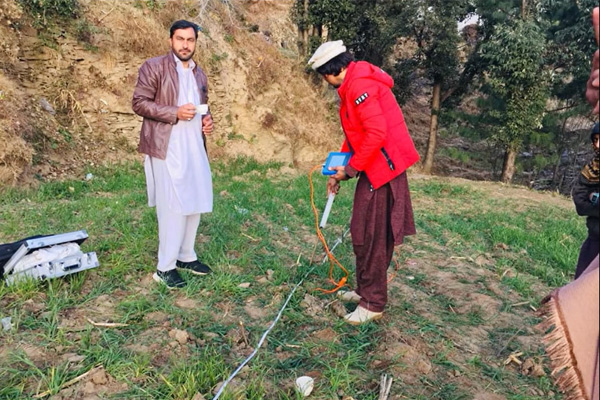
The core of the water finder lies in the frequency selection technology. Geological bodies with different depths and properties, including aquifers, have unique electrical response characteristics to natural electric field signals of different frequencies. For example, groundwater, as a good conductive medium, has a significant difference in conductivity from geological bodies such as surrounding rocks. When the natural electric field signal passes through different geological bodies, the signals of different frequency components will be selectively absorbed, scattered and reflected due to the different electrical properties of the geological bodies. Through a specific frequency selection device, the water finder can collect and analyze these natural electric field signals of different frequencies.
For the detection at a depth of 300 meters, it is achieved through a comprehensive analysis of the penetration characteristics and response characteristics of signals of different frequencies. Low-frequency signals have a strong ability to penetrate deep into the subterranean area. When the low-frequency natural electric field signal propagates to 300 meters underground and encounters the aquifer, the electric field distribution, potential difference and other parameters of the low-frequency signal will change due to the high conductivity of the aquifer. The water finder uses a high-precision electric field measurement sensor to capture these subtle changes and convert them into electrical signals for recording. At the same time, combined with the detailed response information of high-frequency signals in shallow strata, a comprehensive model of geological structure and electrical properties from the surface to a depth of 300 meters underground is established.
The signal processing and analysis system inside the instrument is critical. The acquired natural electric field signal is very weak and mixed with various interfering signals. First, the signal is amplified by a preamplifier to increase the signal strength for subsequent analysis. Then, advanced filtering technology is used to remove unwanted signals such as environmental noise and electromagnetic interference, and retain effective signals related to underground geological structures. The digital signal processing algorithm is used to analyze the spectrum and phase analysis of the effective signal, and the characteristic parameters that can reflect the location, scale and water richness of the underground aquifer are extracted. The presence of groundwater and the relevant parameters of groundwater at a depth of 300 meters were determined by comparative analysis with pre-established geological models and databases.
Based on the in-depth understanding of the characteristics of the earth's natural electric field, the clever use of different frequency signals in the underground geological body propagation and response differences, combined with advanced signal acquisition, processing and analysis technology, realizes the accurate detection of deep groundwater resources, provides important technical support for the exploration and development of water resources, and plays an irreplaceable role in hydrogeological exploration, water search in arid areas and other fields.