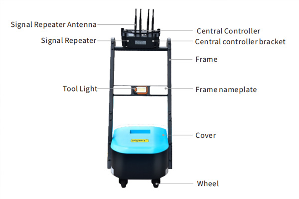

The automatic map-forming water detector developed by PQWT Research Institute provides strong support for water detection work with its unique bipolar profile technology. This colorful contour color map reveals the differences in the conductivity of underground rocks through the contour lines of different colors, which in turn provides us with clues to find water. So, how to detect the colors and identify water from this map?
1. Understand the relationship between the color bar and the numerical value
Looking for water on the right side of the profile, there is a row of color bars, from red to blue is divided into 18 color blocks, each color block is marked next to the corresponding value. These values represent the range of potential differences represented by that color bar. At the top of the color bar is red, which represents the maximum value of the potential difference. By calculation, we can learn the upper and lower limits of the potential difference represented by each color block. It is important to note that these values are not fixed, but are adjusted as the measurement conditions change.
2. Identify the relationship between color and electrical conductivity
In a water finding profile, the colors and values indirectly reflect the conductivity of the rock. The closer the area is to the red color, the worse the conductivity is; while the closer the area is to the blue color, the better the conductivity is. This variation may be caused by a variety of factors, such as the hardness of the rock, the water quality, the content of conductive minerals, and the fracture rate. Therefore, we need to take these factors into account in order to more accurately determine the distribution of water.
3. Search for abnormal changes
In the process of finding water, we need to pay attention to the abnormal changes in the map. These anomalies include both the abnormal changes in color and the abnormal shape of the contour lines. For example, sudden change of color, change of density of contour lines, jagged, folded, V-shaped or inverted V-shaped form, etc., may be important clues to find water. When observing the anomalies, we should mainly observe horizontally, supplemented by vertical observation, and combine the original map and processing map for comprehensive analysis.
4.Analyzing the influence of lithology and structure on water searching
Lithology and tectonics are two important factors affecting water finding. Brittle and hard rocks are usually more suitable for drilling wells than soft rocks. In the figure, if the blueish area is large, it may mean that the lithology is poor and the fissures are not developed, which is not favorable for finding water. However, in some cases, such as localized bluish areas in a predominantly reddish diagram, it may mean that there is less abrupt change in lithology and a greater likelihood of increased fracturing, which is conducive to finding water.
5. Finding reddish areas in blueish areas
In some cases, we need to look for reddish areas in the blueish areas to determine the well location. For example, looking for gneiss in rocks dominated by schist, or gravel in rocks dominated by mudstone. These reddish areas usually have better lithology and more developed fissures, which are favorable for drilling wells for water.
6. Identifying the color of Quaternary gravel layers
For Quaternary gravels, their color on the map depends on the conductivity of the underlying strata. If the underlying strata are poorly conductive mudstones, the gravels may appear reddish in color. When searching for water in the gravel layer, we should focus on areas that are shallow, thick and dark reddish in color. However, it should be noted that due to the downward transmission of high-value layers, the reflected interface under the sand layer may be larger than the actual depth.
By analyzing the pqwt ground water detector profile, we can effectively identify the distribution of water. In the process of water searching, we should comprehensively consider a variety of factors and make judgment and decision in combination with the actual situation, in order to improve the success rate and efficiency of water searching.